Edward Triplett, PhD
I am an Assistant Professor of the Practice in the Art, Art History and Visual Studies Department at Duke University and a member of the Wired! Lab. I teach courses on the design and construction of castles, monasteries and cathedrals during the medieval period, as well as a course on the application of GIS for the study of historical subjects. My field research and publications have focused on the architecture of Iberia’s military-religious orders during the Christian reconquest of Iberia, and the fortified border between Portugal and Spain during the 15th and 16th centuries.
Portfolio
RESEARCH

- 3D GIS Mapping
- 2D GIS Mapping
- Image annotation
- Database building
- On-site survey
- Terrestrial and drone-based photogrammetry
- On-site photography
- Procedural Modeling (Sandcastle Workflow)
- Book of Fortresses @ Duke Digital History & Visual Culture Research Lab
- Duke Digital Humanities - The Book of Fortresses
- Book of Fortresses in Out of the Archives: Digital Projects as Early Modern Research Objects

- Spatial humanities toolbuilding
- Procedural modeling
- Image annotation
- Chorography Research
- Sandcastle Workflow @ Duke Digital History & Visual Culture Research Lab
- Building Sandcastles with History: Recreating the Vision of Pre-Modern Mapmakers
- Duke Bass Connections: Mapping History: Seeing Premodern Cartography through GIS and Game Engines (2020-2021)
- Duke Data+: Computational Approaches to the History of Cartography
Atalaya Project
- Continuation of the Architectural Database of Iberian Military Orders (ADIMO)
- Consultation with two students extracting dates and locations of 19 th century catalogs of Medieval and Early Modern charters of Portugal and Spain
- Viewshed analysis, network analysis, and cost-distance analysis in ArcGIS Pro and ArcOnline
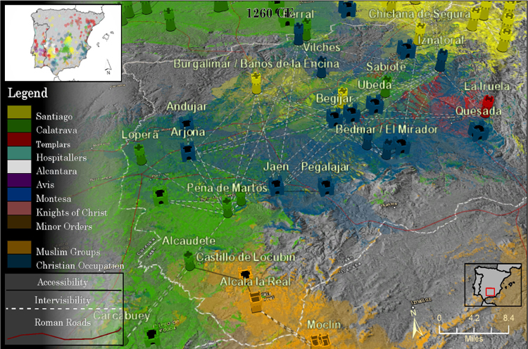
- Spatial study of the Medieval Christian conquest of Muslim Iberia
- Mapping Spheres of Influence on Medieval Iberia's Religious Frontier via Viewshed Analysis and Cost-Distance Analysis
- ADIMO Timeline - Viewshed Analysis on the Frontier

- Georeferencing 150+ topographic maps of Duke property in 1925
- Construction of historical digital elevation model
- Vectorization of dwellings, utilities, woods, etc. into GIS
- Asset development for “Visualizing Cities” Spring 2023
- Supervision of two students Fall 2022
- Duke Plats Map

- Used 3Ds Max software to create an animation of gold leaf on a digitally “revived” simulation of the Ghessi Alterpiece.
- Project Lead: Ingrid Daubechies
- Reunited: The Ghissi Altarpiece
PEDAGOGICAL

- Monument and site scanning of Geer Cemetery
- Collaboration with the Friends of Geer Cemetery
- Object photogrammetry
- Site-scale GeoSLAM LIDAR training and experimentation
- DGPS survey training with REACH RTK devices
- The Archaeology of Death at a Southern Black Cemetery
Duke Chapel Photogrammetry Workshop

- Training of ca. dozen graduate students and staff in photogrammetry shooting and processing
- Execution of 128 million point interior scan of Duke chapel
- 3D Duke Chapel
- Crowdsourcing a Virtual Duke Chapel

- 3D digitization of special collections Chinese Seals
- Construction of popup photogrammetry studio in Clemons Library
- The Virtual Museum
CONSULTATION
- Photogrammetry processing and consultation for scanning of collections of the Nasher Museum of Art
- Art of the Americas Interactive
- Cultures of the Sea: Art of the Ancient Americas

- Consultation on grad student project lead by Phil Stern
- Tracing the worldwide sites associated with British corporations 16 th to 19 th century
- Modeling Sovereignty
- Kite and pole aerial photogrammetry
- Site scanning at archaic period cite of Cittadella at Morgantina, Sicily
- Duke Classical Studies Blog by Tim Shea
Snow Hill Plantation Cemetery
- GeoSLAM LIDAR training and experimentation
- Project Lead: Brian McAdoo
GRADUATE VISUALIZATION WORK AT IATH

- 3D Modeling of construction phases
- English Medieval Architecture: A Model For Design Process Analysis
- Project lead: Lisa Reilly


- Minor texturing and modeling of statues
- www.romereborn.org
Grants
The Sandcastle Workflow: A Malleable System for Visualizing Pre-modern Maps and Views
National Endowment for the Humanities. 2020-2022
Mapping History: Seeing Premodern Cartography through GIS and Game Engines
Bass Connections, Duke University. 2020-2021
Computational Approaches to the History of Cartography
Data+, Duke University. 2020
Affiliated Projects
Virtual and Augmented Reality for Digital Humanities Institute (VARDHI)
National Endowment for the Humanities. 2017 to 2020
Building Duke: The Architectural History of Duke Campus from 1924 to the Present
Bass Connections, Duke University. 2018 to 2019
Teaching
Duke University
Mapping History with GIS: Fall 2017, Fall 2018, Spring 2020
Beginner/Intermediate/Graduate Geographic Information System (GIS) course designed to help students learn how to investigate history spatially. Emphasizes perspectives, procedures, and tools that are relevant to applications of GIS in Art History and Humanistic disciplines. Designed as a hybrid lecture/lab format in which direct instruction is supplemented by hands on learning labs using ArcGIS software and real-world spatial data. The main skills students will gain are: integration of spatial and tabular data, geoprocessing, data visualization, creating features, editing features, vector and raster integration, spatial analysis, georeferencing.
Gothic Cathedrals: Fall 2017, Spring 2020
Great cathedrals of Europe in England, Germany, and Italy, with a special focus on France, from roughly 1140 to 1270, and their construction, financing, and role in the fabric of medieval city life. The urban context of each city, the history of the site and its relics, and the artistic and technological developments that made the construction of these complex and large-scale structures possible. A consideration of Romanesque precedents and the origins of the various structural elements of Gothic architecture.
Exploring Art and Architecture: Fall 2019
Provides knowledge for developing skills in visual analysis and historical interpretation of art from antiquity to present; examines major theoretical frameworks, key movements and concepts; explores how we look at and talk about works of art, investigating a variety of approaches to their study, including artists and their material practices; biography, patrons and the public; built environment and cultural institutions; how the social and political roles of art change through time. Taught in Nasher Museum. Classroom discussions complemented by visits to Nasher galleries and direct practice of visual analysis, critical theory, and role of changing histories in comprehension of art. Co-Taught with Prof. Susanna Caviglia.
Medieval Castles of Europe: Fall 2016, Spring 2018, Spring 2019, Fall 2019
This course will examine the transition of Western Europe into a fortified landscape from the mid-11th century until the advent of large-scale artillery in the mid-15th century. In addition to tracking technological and stylistic changes over time, this course will identify the discrete elements of fortification that were combined into a variety of castle plans. Natural resources and physical topography will emerge as central factors in the choice of site and design for medieval castles. As a way of investigating these topics, students will digitally reconstruct a historical or imagined castle in 3D graphics at a specific place and time covered in the course.
3D Modeling and Animation: Spring 2019
Basic concepts of 3D modeling and animation; fundamentals of computer geometry; knowledge of basic tools of 3D software (Maya); introduction to modeling, animation, texturing, lighting, and rendering; combination of these techniques in a final project.
Medieval Monasteries and Cathedrals: Fall 2018
This course introduces students to the history and design of cathedrals and monasteries in medieval Europe. Themes include the development of Gothic architecture from Romanesque foundations in France, the importance of fractions and Euclidean geometry for medieval architects, and the material and financial costs of monumental construction projects during the middle ages. In addition to lectures and discussion, students will design a counterfactual monastery or cathedral using 3D graphics software as part of a final project. In-class tutorials will teach students how to draw plans, elevations and sections of churches and monastic buildings and how to build 3D models from these drawings.
Senior Capstone in Visual & Media Studies: Spring 2018
Capstone seminar focusing on advanced visual studies theories, as well as individual senior projects undertaken as a written research paper or visual production.
Visualizing Venice Summer Workshop - Advanced Topics in Digital Art History
3D Geospatial Networks: June 2016, 2018 & 2019
3D GIS & Viewshed Analysis
3D Data and Historical Visualization
Lecture/Discussion: Emergent Tools for Digital Art Historical research
Photogrammetry shooting techniques (2016)
University of Virginia
The Virtual Museum: Spring 2015
Project-based seminar for undergraduates on the theory and practice of virtual museum exhibits. Focus is on the complex relationship between architectural space and exhibit curation in museums through critical reading, museum site visits, and hands-on creation of virtual exhibits for online delivery.
Course website: The Virtual Museum
A Critical Approach to Digital Humanities: Fall 2014
Co-Instructor With Prof. Lisa Reilly
Course designed to increase the digital literacy of advanced undergraduate and graduate art & architectural history students. Class meetings combined discussion of readings and analysis of sites and tools with hands on instruction in a spectrum of digital tools relevant for art and architectural history.
A History of Architecture: Summer 2014
Intensive 4-week, 3 credit survey on the history of western architecture.